Author Archives: pixyledpublications
Noted springs and wells around Tunbridge Wells: The Chalybeate spring and the Burnt House Spring
Undoubtedly the most famous healing water in Kent and perhaps one of the most well known in Europe is The Chalybeate Spa. Its discovery can be outlined briefly as follows, being uncovered by chance in 1609, by Robert Dudley, whilst he was riding back to London, stopping by a densely wooded hollow, beside a stream. Here he noticed a reddish-rust coloured pool. Dudley being a hard drinker was familiar with the fashionable European spa waters, and noticed a resemblance! Indeed, upon drinking some, he found that the water was also similar in taste. Realising its potential, he took a sample to his physician for analysis. This showed traces of vitriol ferrous sulphate, then considered to have some medicinal power. Such vindicating news pleased Dudley, who returned the following summer to undertake a treatment, after which he found himself healthier. Perhaps the water was lengthened his life, for he lived to 84! Fortunately, exploiting the spring was easy, as it lay within the Abergavenney Estate, who being an acquaintance of Dudley, and subsequently the pool was cleared and cleaned out, and a well sunk, to improve the quality. This work revealed that the waters arose from seven springs.
By 1619, the whole area was enclosed in, and marked off with wooded rails. Already, it was much frequented, but a lack of suitable accommodation, affected trade. Even Henrietta Maria, visiting for six weeks in 1630 to recover after the birth of the future Charles II, had to camp out at Bishop’s Dun Common, like the rest of her court. This, and the increased interest as a result of a treatise extolling their virtues by a Dr. Rowse, heightened these accommodation problems, so Assembly room, walks and accommodation constructed and by the late 1600s stalls and facilities and a season between May and October established. As the original 1780 Bath House only administered cold baths, new heated baths were constructed in 1802-4. The remains of this later bathhouse are now beneath Boots the Chemist. A Victorian pump room was constructed at the south end of the Pantiles, with a fountain, reading and retiring rooms. These would appear to have been too late a development, soon falling into disrepair, finally being demolished in 1964. Despite its decline, the waters can indeed are still served by a dipper from Easter to October.
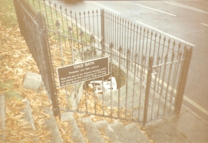
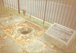
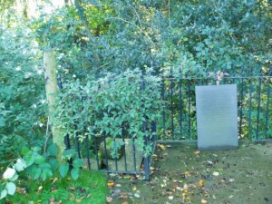
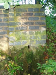
Other relics of the spa’s can be found such as one of the earliest cold baths and one of the original brick-lined shaft wells. The cold bath is now dry and filled with litter, but the well may have some trace of water. Beside each are suitable plaques describing their histories:
“COLD BATH Probably mid-18th Century. Near the site of the Dipper’s Houses which are shown on Kip’s engraving of 1718 and on John Bowra’s maps of 1738 and 1739.
CHALYBEATE SPRING: Probably one of the seven springs discovered c. 1606. The lower stonework is c.1700: the brick dome early 19th century. The site is marked on John Bowra’s map of 1738 and 1739, and archaeological and documentary evidence suggests medicinal use.”
A local legend records the origins of the waters. The Devil, appearing as a beautiful woman, tried to distract the St. Dunstan at his forge, being far too clever and pious to be put off he saw his cloven hooves, turned around and clasped his nose with his red hot tongs. Flying off in a furious rage he found the springs and upon cooling his nose produced its iron waters. A story also associated with the Roaring spring in Sussex.

On the road to Pembury was another attempt to exploit the chalybeate springs of the area. Called Burnt House spring Britton in their 1816 Descriptive Sketches of Tunbridge Wells and the Calverley Estate notes it is:
“…situated in a little dell, in a romantic spot to the right of the road leading from Tunbridge Wells to Pembury. It is a good chalybeate, and the iron is in a state of carbonate. This spring rises rapidly into a stone basin, placed in the centre of a circular excavation, about ten feet in diameter and six or eight feet deep, which is bricked round, and with the remains of stone steps leading down to the basin at the bottom. This spring, therefore, has clearly been, at some time, made use of as medicinal water. It was accidentally discovered choked up with rubbish. The country about Tunbridge Wells abounds with springs of this character.”
When the estate was developed into Dunorlan Park Henry Reed the spring was retained and improved. The site, possibly with the fabric oldest in the area, arises in a square chamber with a circular basin surrounded by bricks; the water then flows down a channel into as drain. Four large stone steps lead down into the chamber and the hole is brick lined. In a way this is probably what the original development of the chalybeate spa was.
Taken from Holy wells and healing springs of Kent
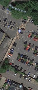
A lost Hertfordshire well – St John’s Well, Berkhampsted
The town once boasted the most famed well in Hertfordshire, which was called St. John’s Well. The earliest dedication would appear to be St. James, as it was associated with a chapel to the saint on the south side of the main road. Apparently it gained the other dedication when a guild of the brotherhood of St. John the Baptist took over its care.
Thus its history is a little confused and probably tainted by antiquarian half truths. For example after the establishment of nearby monastic society in the Saxon period, the monks were obviously distressed to find such pagan activities continuing. Rather than forbid any such activity, one monk, through a dream, was told the solution. He should re- dedicate the well to St. John the Evangelist, and thus create a Christian focus for the sick who bathed here. Although successful, it did not apparently stop all such ‘pagan’ worship. Indeed, in the late 1100s it is reported that Hugh of Grenoble, Bishop of Lincoln journeyed the considerable distance to prevent „pagan‟ activities such as dressing the well, although there is no record of this in the appropriate documentation of the period. Certainly a fair on St. James’s Day may have been established to overcome these problems. Travelers of all types refreshed themselves at the well, benefiting from the healthy waters, and would rest at the monks’ hospitality: little booths being built to house travelers.
Its waters were believed to cure a variety of ailments: eye soreness, Kings evil (scrofula), and leprosy. Suffers from the latter problem apparently were looked after in a leper hospital. All these ailments were commonly experienced by the crusaders, and hence it received heavy patronage during this period. Water was even carried to those unable to reach the well, receiving an extra blessing from the conferred to the person. This however was frowned upon and fines were imposed for such activities, such as in the 1400s when two officials of the Portmote Court were appointed to protect the spring (then the town’s principal supply) from such spoilage. The last noted of these officials was a Geoffrey Fitz Piers, of the said brotherhood.
When the Reformation dissolved the monastic society; the monk’s houses, landscaped gardens and the spring, became broken down, derelict and overgrown. With the lack of any Christian overseers, apparently the old ways resurged. People began to assemble at night, to undertake rituals. In the 17th century a local physician, Dr. Woodhouse, used the holy water to use against frenzy: exorcising evil spirits. Despite containing ‘spa salts’, it was not exploited and 1865 the water was declared by the local authorities to be unfit for drinking, and should be used only for gardens.
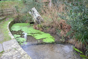
Until the 1930s the well’s water still flowed over stones and down a shallow channel along St John Well’s Lane when a post office was built over the site of the leper. Now the post office is gone and housing over the site. The well being lost forever.
Taken from Holy wells and healing springs of Hertfordshire.
The ancient, holy and healing wells of Bodmin Part four: St Petroc’s Well
 The last notable well is the town is that found in the local park. This is what is now called St Petroc’s Well has gone through a number of name changes. In 1635 it was called St Guron’s well and in 1639 St Jerome’s Well although this may itself derive from a mispronouncation of the Guron! Thus there appears to have been some confusion with the site by the church and their names appear to have been interposed. Hence many of the early records such as Quiller-Couch miss it.
However, the Petroc association is supported by the well arising in the lands of a monastery said to have been founded by St. Petroc in the 6th century. Tanner records British monks following the rule of St. Benedict about 936. The community existed until about 1124 when it was re-formed for Augustinian Canons. Priory House was built on the site and remains today at the edge of the park.

A marvelous discovery
A wooden statue of St. Mary was actually concealed inside the well to protect it from Cromwell’s troops. Incredibly it was only found at the very beginning of the twentieth century. After minor repairs and redecoration at Buckfast Abbey, it was returned to Bodmin where it is found in St Mary’s church, whether it was originally from there or the monastery is unknown.
The well today
The well arises in a stone lined chamber at the end of a streamlet beyond the stone channel edge. It is often covered in water as it was nearly completely cover when a flood alleviation system was established in 2001 by the Environment Agency such that only around 30% of the stone structure is visible. A secret mysterious place in a modern park.
Liskeard’s marriage well – St Martin’s or the Pipe Well
Urban areas are not good for wells but Liskeard has retained one of the largest and impressive site called St Martins or as signs state in the town, the Pipewell. In Fortesque Hitchen’s 1784’s History of Cornwall he describes St. Martin’s Well as follows:
“ There is a house standing near the bottom of the town, which from its windows, gateway, and sculptured ornaments, appears to have been formerly connected with some religious establishment. Near this building issues the spring which supplies the inhabitants with water. The excellency of this salubrious fountain is deservedly held in high estimation. Conscious of its intrinsic value, the credulous inhabitants of former ages attributed to it some miraculous virtues, which fancy still continues to cherish with fondness, even to the present day. ….The stream on becoming visible is divided into three parts, all of which have some peculiar efficacy; but one branch far surpasses the others in its potent qualities. A stone that is deposited in the well is presumed by tradition to have a considerable influence over the matrimonial connections of any fortunate female, who, under given circumstances, and at an appointed time, shall have the happiness to touch it with her foot. These tales are still kept alive, and the ceremonials are practised by the young and thoughtless to the present hour.”
The age became less credulous as years went by; for Gilbert in his Survey of Cornwall , vol. ii, writes:
“ Liskeard has one of the most commodious wells that we have seen in the county, and which was formerly crowded by superstitious visitors. The water falls into a stone reservoir from three shutes; and that which flows from the central one was in former times believed to possess the greatest healing efficacy. The well is still plentifully supplied with transparent water; but the credibility of its sanative virtues has evaporated like the morning dew which is exhaled by the rays of the sun.” St. Martin’s Well has changed its title in these later years, and is now commonly spoken of as “ Pipe Well,” from the pipes through which the water flows, the number of which is now four. It stands at the back of the marketplace, and is kept in a state of good repair, for its water is in general use. The magic stone is said to be still in the well but is now covered over and its virtue gone.”
Antony D. Hippisley Coxe in his 1974 Haunted Britain adds that it was also believed to possess miraculous healing powers and would cure “weak eyes” and RA Courtney in his folklore and traditions of Cornwall noted:
“St. Martin’s well, in the centre of Liskeard at the back of the market, known as “Pipe Well,” from the four iron pipes through which four springs run into it, was formerly not only visited for the healing qualities of its chief spring, but for a lucky stone that stood in it. By standing on this stone and drinking of the well’s water, engaged couples would be happy and successful in their married life. It also conferred magical powers on any person who touched it. The stone is still there, but has now been covered over and has lost its virtue.”
The current sign at the well reads:
“Place of Sweethearts It is claimed that the following ritual would improve matters of matrimony. Kneel with the right knee on the magic stone, plunge a hand into the water up to the wrist and drink from the palm of the hand. Whilst on the stone a wish is made which will be fulfilled within one year, provided it is never uttered aloud. One Liskeard resident remembers that when working as a maid in Stuart House during WWI, some other maids would sneak off to Pipe Well via a system of underground tunnels to meet their sweethearts.”
One would also think that as the spring arises in a dark recess in an not overlooked location this may also help in matrimonial issues!
It is unusual to see an urban spring still flowing especially as many were tapped for domestic supplies, increased groundwater demands, or capped due to pollution concerns and although Drew notes:
“The source whence this water issues is acknowledged to be involved in a kind of indefinite mystery, so that even curiosity is content to let it remain unexplored.”
Its source is now and is due to its geology a fault called the Portwrinkle fault runs under the town and those has a positive effect on the towns ability to store water. This combined with the underground sources of the River Seaton and East Looe river has meant that that the well’s supply is fairly limitless.; currently it an estimated 136 litres are produced every minute.
Despite the copious the Borough was always keen to protect the source from use. In 1503 five persons appeared before the Magistrates accused of washing skins in “le trough at the Pype-well”. Regulation 10 of the Borough Constitution of 1587 stated that “no inhabitant shall wash at the town well any pilchards, pots or any other filth; but bring some vessel and wash the same therein”. The current sign reads:
“Many residents can recall a sign which reminded owners of pigs that “Bellies must not be washed in the Well”.”
However, by the mid-1800s tradespeople and travellers staying at the nearby Talbot in would use the water to clean themselves. The sign reads:
“One of the last traders to collect water from the Pipe Well every day was barber Erwin Hicks of Fore Street. Mr. Hicks was a member of Flying Corps during WWI, he unfortunately suffered a heart attack and died during his last visit to the well.”
By the late 1800s improvements were needed and so by 1879 granite from the nearby Cheesewring Quarry was used to restore it and four new pipes were installed and gates placed which prevented people now accessing the magic stone. These remain and are currently adorned with circular garlands of crocheted flowers. A fascinating survival.
Holy well or mineral spring? St Catherine’s Well near Southwell
The small hamlet on the edge of Southwell called Westhorpe, has the supposed remains of St. Catherine Well. I state supposed it because this is one of those sites which may have been a post Reformation pretend holy well. There is evidence of the site having a chapel; earliest record of a religious institution here being in 1482 when a chapel was erected dedicated to the saint. When researching the site for my book on Holy wells and healing springs I was unable to locate this source
’to build a chapel close to the well called St. Catherine’s Well in honour of St. Catherine the Virgin and an indulgence for five years to all those helping to build the chapel’.
Of its post-Reformation history William Dickinson in his 1819 the Antiquities and history of the town of Southwell notes that a Mr. Burton of Norwood Park built a house and bath at the site in 1720. This is found down Bath Lane which remembers the fact that it site was once developed as such. He appears to have used the saint as support for its properties as:
“Over the head of the fountain was a plate, on which some Latin verses were inscribed, much to the honour of the tutelary saint, and the reputation of the water.”
Its waters were said to be a cure for rheumatism being particularly cold as noted by Richard Shilton in his 1818 History of Southwell:
“This water, which was peculiarly cold, was renowned in the days of yore, for its many virtues ; perhaps it did possess and doubtless would have retained them to this day.”
It is thought that the cottage and barn at the site may be the remains of this spa venture, although, I was informed by the occupant that the barn had mediaeval features such as moulded features, suggesting perhaps this was the remains of the chapel. When Robert Morrell in his 1988 Holy wells of Nottinghamshire visited he was also told that a bath-like structure with steps down was located nearby, but an exact location was unknown, and the current occupants were similarly unaware of it when I visited. However, I have subsequently learned that it is just below the well head but I have not returned to check. This was probably a relic of its Burton’s exploitation. This appears to have been a brief period, for as Shilton (1818) notes:
“…would have retained them to this day, had there been the due accompanyments (sic) for luxurious lounge, intrigue and scandal commodiously attached.”
St. Catherine’s Well itself is found between Bath Cottage and the barn. It arises in a brick-lined square structure capped with a broken slab. This sits on an older has the appearance of calcareous rock; although any petrifying properties are not noted by previous authors. When first visited the well house was dry, however, a more visit in spring showed a considerable flow (despite a dry winter). It flowed from a clay pipe within the well house and leaves through a smaller pipe set into the calcified part and then down to the dumble below. In this dumble appear to be some dressed stone which may have been part of the original structure. Beside the well on the bank above is a small slate monument which records:
“A chapel dedicated to St. Catherine existed here in medieval times but it is thought to have fallen into disuse at the dissolution. A spring and well with reputed healing properties near the chapel was still patronised in the 1800s by those seeking relief from rheumatism. The present bath cottage was erected on the site of the chapel. D.J Hall Southwell.”
The grounds are private although I was welcomed when I visited, there is a path the other side of the site of the well which may give a better view of the site however.
The mysterious Powdonnet Well, Cumbria
 Powdonnet Well is a curious site, a large clear and deep pool lined by a wall of rocks, full of spring water beside a fast flowing stream and cloaked in the shadow of a copse of trees marked by a modern monolith which records its name, the relic of a Millennium cleaning up, although other sources suggest 1995! It is an evocative site, but its history is challenging.
The pool lays on the edge of the small settlement of Morland. The church it is claimed lays upon a pagan site and boasted a shrine within. The relics of St Laurence were laid in 666AD in a stone altar within giving the Saxon church a religious focus. This was apparently lost at the Reformation but local tradition records that it was buried somewhere in the churchyard.
Powdonnet derives from the Irish-Gaelic “pow’ meaning pool and donnet referring to a saint called Donat meaning the ‘Pool of St Donat’. Smith in his Place-names of Westmorland 1967 cites that the earliest form was in 1637 as Powdonet and is not mentioned as Powdonnet Well until 1859.

Who was St Donat?
St Donat was a little known French saint and there are dedications to him in Wales such as St Donats castle,in Glamorgan the church guide referring to:
“The church (St Donats) had originally been dedicated to the Welsh, St.Gwerydd, but in Norman times the dedication had been changed to St. Donat, or St. Dunwydd, as it is written in Welsh.
He was a ninth-century saint who is said to have been born in Ireland and who later became Bishop of Florence. For a long time he was very popular on the north coast of France as a patron saint of sailors.”
But how is this saint associated with a spring in Cumbria? This is particularly problematic as there are no local churches so dedicated nearby and the church does not share its dedication. However, it is possible that it records a Celtic dedication lost to the Anglo-Saxon expansion; the last relic of the saint’s association locally. Certainly, it is a primitive site one might well expect associate with the early baptism of a Celtic evangelist. Was this St Donat? What is more remarkable is that unlike many other well sites which have been enclosed in brick and stone, this site retains what it must have been like back in those early years.
St Cleer’s Well, Cornwall – a cure for insanity?
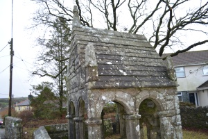 Recently I had the opportunity to visit one of Cornwall’s most impressive holy wells, St Cleers well on the edge of Bodmin Moor at St Cleers. A Lane-Davies in this 1970 Holy wells of Cornwall is very clear that this is:
“Not St Cleer’s well but the holy well in the parish of St Cleer.”
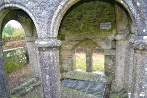
This is one of Cornwall’s most impressive wells and indeed has a fairly unique structure, having open arches on all sides and in all intents and purposes resembles a shrine and perhaps may have held relics – although this would indeed make it unique. It is more probable that it would enable more people to access the waters
William Hals in his 1700 Parochial history of Cornwall is the first to record the site:
‘In this parish is yet to be seen a famous chapel Well, dedicated to S. Clare, a work of great skill, labour, and cost, though now much decayed . . .’
Lane Davies states:
“During the Reformation and later days of political strife these structures were neglected and fell into ruin…the road encroached on the site and the first cistern filled in.”

He continues:
“illustration..of an ancient print…shews the utter ruin of the building of the site. In 1855 Lt Henry Rogers RN purchased from a local miner the ‘waste spot and ruins called St Cleer’s Well, comprising of the ancient well chapel and 61/2 perches of land. Water still flowed from the well out into the ruined bowssening pool, a muddy irregular pond villagers brought their animals to.”

Indeed it had certainly became ruinous around this and became the focus of a number of romantic illustrations. Quiler-couch notes:
“ When I visited this interesting well in 1850, and made the sketches of it here appended, it was a very pretty group of ruins. The cross, of Latin form, about seven feet high and recededed on both sides, stood near the well, the front of which, partly enveloped in ivy, was fairly entire. The arches and buttresses, well moulded, showed it to have been once a work of great skill, labour and cost. The entrance was by a double arch, the central mullion being imperfect. The back of the well was down, and the space partly filled with the sharply-cut and well-fashioned ruins.”
Addition he notes:
“In 1864 it was restored by the family of Rogers of Penrose, near Helstone, to the memory of the Rev. John Jope, for sixty- seven years vicar of the parish, as is recorded on a slab in the wall.”
Restoration was done by Liskeard based architect Henry Rice, ensuring that its restoration was in keeping with its original medieval that the improvements over 150 years later look indistinguishable.

Who was St Cleer?
Charles Hope in his 1893 in the Legendary Lore of Holy Wells tells us via Hals that they were:
“born of honourable lineage at the city of Assisum in Italy, in the province of Umbra; and being from her youth a practiser of the Christian religion with great zeal, she became desirous to follow a religious course of life ; and to that end applied herself to St. Francis, who lived in that city, and made known the same to him ; who greatly commended her for it, and soon after consecrated her a nun by cutting off her hair, and apparelling her in the habit of the order of the Nuns of St. Benedict. He carried her to the monastery of St. Paul in that city, which was of that order, where she remained till St. Francis had repaired the church of St. Damian, without the city, in a solitary place, wherein he set her ; in which she was closed up in the love of Jesus Christ, and there begun or set up a college of virgins called the Order of the Poor Clares of St. Benedict , under the solemn vows of obedience, poverty, and chastity, according to the rule of St. Francis/’ St. Cleer’s Well is said to have belonged to a nunnery, once extant either in this parish or at Liskeard, of one of the three Orders of Poor Clares.”
Traditions of the well
Quiller-Couch notes that:
“The water is good and plentiful. I tried to gather something of the legends connected with the well, but was only told tantalisingly that there were many strange stories about it, that it was still held to have miraculous virtues, and was resorted to by the halt and the blind. I could get no confirmation of the statement that it was once a bowsening pool”
A bowsening pool being a pool used to treat madness of which there are other examples in Cornwall. One wonders if the placement of a stone over the main part of the pool was intentional to prevent this. Of this there appears to be no other tradition other that there is the stones were cursed:
“Many of our Cornish wells have, as in the case of St. Nun’s in Pelynt, 1 some tradition connected with them, intended by those who first gave them currency to stay the hand of the destroyer. This has been so saved that it would not be difficult to effect an entire restoration from the ruins which lie scattered round. I learnt from a native of the parish that some of the stones of the well have been at various times carted away to serve meaner purposes ; but they have, by some mysterious agency, been brought back again during the night. This account describes St. Cleer Well as it was in the year 1850.”

Currently, the site has become a small rag well with ribbons and other offerings being made. More recently a new tradition appears to be emerging, when the Cornwall Heritage site acquired it they revived or introduced well dressing. Their website records :
“Cornwall Heritage Trust celebrates new historic site by reviving well dressing in St Cleer
We celebrated the acquisition of our 13th historic site, St Cleer’s Well, last Friday by reviving the annual tradition of dressing the monument.
In spite of the rain, the event had a truly joyous atmosphere. The artwork created by the children from St Cleer Primary School for the event was wonderful, as was the vibrant array of posies they laid at the well as part of the ceremony. After the blessing, readings in Cornish and English and a rousing (if a little damp) rendition of Trelawney, the morning was rounded off with Cornish dancing back at the school – the perfect, raucous end to the festivities!”
Hopefully this will be an ongoing tradition at this evocative well,.
Lost holy and healing wells of London: The wells of Westminster.
Perhaps the earliest holy well recorded in the city, is that associated with a vision of St. Peter by fisherman on Thorney Island before Westminster Abbey was built, is told by Sulcard of Westminster in around 1076 in his The Building of Westminster translated by J. Flete’s 1909 The History of Westminster Abbey. Dating from the days of Abbott Mellitus the founder of Westminster, a bright light was seen by that fisherman on a Sunday night on the opposite Lambeth shore. The ferry then carried across a vision of St Peter who consecrating the new church and as he stepped off onto the shore he is said to have:
“thrusting his staff into the ground behind him he made a flowing spring; then, after he had walked on a little, he thrust in the staff and created another one; and these two springs continued to flow for many years, until at last they were washed away by the river.”
The site was called St. Peter’s Well, and although Sulcard suggests that it was lost two sites surprisingly, were identified by Stanley (1868) as the site a well in St. Margaret’s Churchyard and a pump, in the green of Dean’s Yard. Both are now lost.
A conduit head above St James’ Palace called James Head in 1598 may recall a St. 20 James’s Well, although there is no firm evidence. However, more convincing is St Clement’s Well which is mentioned J Stow’s 1598 Survey of London states that
“the fountain called St Clement’s well, north from the parish church of St Clement’s and near unto an inn of Chancerie called Clement’s Inn, is fair curbed square with hard stone, kept clean for common use, and is always full.”
W. Maitland in 1756’s The History and Survey of London notes that:
“the Well is now overed, and a Pump plac’d therein, on the East Side of Clement’s-Inn, and lower End of St Clement’s-Lane.”
A.S Foord’s 1910 Springs, Streams, and Spas of London reports that:
“the holy well of St Clement… has been filled in and covered over with earth and rubble, in order to form part of the foundation of the Law Courts.”
This appears to be the first specific reference to the change from a draw-well to a pump. D. Hughson (1806-09) London British Metropolis, and T. Allen (1827-29) The History and Antiquities of London both allude briefly to the well, but Sanders (1842):
“The well is now covered with a pump, but there still remains the spring, flowing as steadily and freshly as ever.”
G. R. Emerson’s 1862 London how the great city grew, when discussing the Church states:
“It stood near a celebrated well, which for centuries was a favourite resort for Londoners. The water was slightly medicinal, and having effected some cures, the name Holy Well was applied.”
J. Diprose’s 1868 Some account of the Parish of St Clement Danes Past and Present, a local inhabitant states:
“It has been suggested that the Holy Well was situated on the side of the Churchyard of St. Clement), facing Temple Bar, for here may be seen a stone-built house, looking like a burial vault above ground, which an inscription informs us was erected in 1839, to prevent people using a pump that the inhabitants had put up in 1807 over a remarkable well, which is 191 feet deep, with 150 feet of water in it. Perhaps this may be the ‘holy well’ of bygone days, that gave the name to a street adjoining.”
J. Timbs’ 1853 The Romance of London: strange stories, scenes and remarkable persons of the Great Town states that:
“the holy well is stated to be that under the Old Dog’s tavern. No. 24, Holywell Street.”
Foord (1910) states that other inhabitants believe that the ancient well was adjacent to Lyon’s Inn, which faced Newcastle Street, between Wych Street and Holywell Street Foord (1910) also notes that in the Times of May 1st 1874, reads:
“Another relic of Old London has lately passed away; the holy well of St. Clement, on the north of St. Clement Danes Church, has been filled in and covered over with earth and rubble, in order to form part of the foundation of the Law Courts of the future.”
He also notes that The Standard of the 3rd of September 1874 the site is states that report of the Times was erroneous and that the well was still ‘delivering into the main drainage of London something like 30,000 gallons of water daily of exquisite purity’ and that it would be utilised for the new Law Courts. Interestingly, a contributor to Notes and Queries (9th series, July 29, 1899) draws attention to the following particulars from a correspondent, a Mr. J. C. Asten, in the Morning Herald of July 5, 1899:
“Having lived at No. 273, Strand, for thirty years from 1858, it may interest your readers to know that at the back of No. 274, between that house and Holy Well Street, there exists an old well, which most probably is the ‘Holy Well.’ It is now built over. I and others have frequently drunk the exceedingly cool, bright water. There was an abundance of it, for in the later years a steam-printer used it to fill his boilers.”
Foord (1910) states that:
“In order, if possible, to obtain some corroboration of the Standards statement that the spring existed in 1874, the writer applied for information on the point to the Clerk of Works 2 at the Royal Courts of Justice, who wrote that he could find no trace of St. Clement’s Well, so that the report in the Times (quoted above) is probably correct. The water-supply to the Courts of Justice, he adds in his letter of June 13, 1907, is from the Water Board’s mains… On the Ordnance Survey Map, published in 1874, a spot is marked on the open space west of the Law Courts with the words ‘Site of St. Clement’s Well’ this spot is distant about 200 feet north from the Church of St. Clement Danes, and about 90 feet east of Clement’s Inn Hall, which was then standing. The Inn, with the ground attached to it, was disposed of not long after 1884, when the Society of Clement’s Inn had been disestablished.”
On the edge of the pavement in a metal plaque which records the digging of a well and perhaps this is the improved site of St Clement’s well.
A Sylvanus Urban’s 1852 ‘Antiquarian researches’, Gentleman’s Magazine 2nd ser states that a draw-well beneath the Old Dog Inn was a Holy Well and gave its name to the now lost Holywell Street. However, J. Gover, H. Mawer and M. Stenton’s 1943 Place-names of Middlesex states that the name derives from O.E hol, from ‘hollow’.
The ancient and holy wells of Chollerton Part one – the wells of Colwell
The large parish of Chollerton in Northumberland perhaps has more named wells than other – a survey done in the 19th century recorded the following: Drop well, Level well, Dan well, Deadwood well, Dalla well, Madge’s well, East well, Hollywell, Coppies well, Margaret’s Well, Kate’s well, Crow well, Bank well, Nine wells, Tone well, West well, Bore well, Prickie’s well, Coley well and Robin Hood’s Well. Quite a significant number of wells it appears.
Charles Hope in 1893 in his Legendary Lore of Holy Wells notes of the village or rather hamlet of Colwell:
“This village, in the same parish of Chollerton, derives its present appellation from a well-known spring, not far from the now almost forgotten site of another early capella. With this an interesting relic of primitive worship used to be associated in a popular pilgrimage, and the bringing of flowers, to dress the well on or about Midsummer Sunday.”
It is reported by Northumberland Federation of Women’s Institutes in the 1994 The Northumberland Village Book that:
“where Colwell now stands. There were also three springs – Prickie’s Well, Robin Hood’s Well, and Coley’s Well which was almost certainly the most revered of the three.”

The spring he appears to refer to is Coley’s Well which appears to have associated with a fairly unique custom or rather uniquely named. A report in 1891’s Society of Antiquaries of Newcastle upon Tyne states:
“The well used to be celebrated as the ‘Bridal of Colwell’:”
A name which has a slightly pagan feel to it perhaps, This time the customs is said to have moved to the 4th, although those familiar to calendar customs will be aware that this is Old Midsummer’s Day, the day it would have been before the calendar change:
“The annual festival was held on or about the 4th of July (St. Ulric’s Day), and consisted of a popular pilgrimage to the well at Colwell and dressing it with flowers. This ‘Bridal of Colwell’ is no longer remembered, but it is probable its observance may have been transferred to the ‘Borewell’ in the same district, a sulphur spring at which the local ‘hoppin’ is still held at the Sunday next after July 4th.”
Thus Peter Binnall and Madeline Hope Dodds in the 1941 -1944 in the Proceedings of the Society of Antiquaries of Newcastle upon Tyne, 4th series record that:
“Once called the ‘Bridal of Colwell’, but now ‘Coley’s Well’. It is the only well in Northumberland connected with the custom of well-dressing.”
The custom would appear to have been similar to Spaw Sunday when a certain day was chosen for visiting the well, when the waters were auspiciously more powerful and as a result a social event would develop around it. Interestingly, it appears to have been associated with a significant local history event:
“By the Middle Ages a traditional celebration of one of the wells had been established. This celebration, during which the well was blessed and decorated with flowers, was known as The Colwell Bridal and was held around 4th July on St Ulrich’s day. It was the object of popular pilgrimage and, on one such day in 1534, the good knight Sir Thomas Dacre seized three of the infamous Charlton clan who had travelled many miles to attend the Bridal. The Charltons had attacked Tarset Castle eight years earlier, burnt it and dispatched Sir Ralph Fenwick with his 80 horsemen out of North Tynedale. Their apprehension at the Colwell Bridal not only created local excitement, but also went down in history.”
Why this custom ceased is unclear, perhaps the water failed or the landowner denied access but it would have appeared to have moved to another well called the Bore well, which I shall cover in another future post. Of the Coley Well it still exists. It is noted by a low stone wall which encloses it on three sides and gives access for a large number of individuals and cows (!) suggesting it was indeed constructed for this function. The water flows from one side of the chamber and forms a very muddy pool, but a rectangular basin set into the ground can be seen, however a modern brick building nearby doubtlessly taps the spring.

Of the three other wells very little seems to been recorded other than their names in italics on the early OS map. Pricky’s Well is enclosed in a concrete structure and although flows considerably there is little old remaining and nothing appears noted about its name or traditions other than it was a copious spring. The final well of the three which lay in a line is the Robin Hood’s Well. This is an interesting named site and although modern Robin Hood devotees may visit the area to see the site of the famed Prince of Thieves tree (now sadly gone) few would visit this. But does it have a true association with the outlaw? Probably not, I would suggest that it more likely records an elemental and indeed the springhead, the most undeveloped of all, is very evocative of mysterious water beings. It arises to fill a boggy hole with a single stone to mark it. Again little is know of it but from the pipe leading off it it still has a use.
The ancient, holy and healing wells of Bodmin: Part three – the Bree Shute and Cockwell
Good eye water
Two less well known springs which have widely differing effects. Near the car park off Dennison Road is a rare survival that other towns would have culverted, this is the Bree Shute or as the sign proclaims the Eyewell. The stone tablet is a survival from 1700 and records the use of the water for those who had ocular problems, as readers of this blog will be aware, a common concern. However, the oldest record of the well is recorded as Breest in the account rolls of those tenants playing rent living on hillside east in 15th and 16th Priory accounts. Its other name from the Cornish Bree for hill.
Fever grips Bodmin
Throughout the 19th century, enteric fever was a common issue and claimed many people. In 1872 a Rivers Commission report stated that the water “a fairly good •, water”, however analysis did show it was highly contaminated and may have been a source of illness. This is certainly true of the other well, for the Cock Well had a less savory reputation. The well supplied water for the area as well as a blacksmith nearby but in 1881 Enteric Fever, hit the town and 60 cases of the fever being reported with 13 fatalities. Two fatalities were blacksmiths which was significant because the often drunk large quantities of water due to the hot conditions they worked under. For one of them it was certain that the Cock Well was the culprit but unlike in other towns it was not filled in and remains today.
Oddly enough, the name Cock may derive from the name Couch. There was a Couch’s Lane in the town where the renowned . Sir Arthur Quiller Couch author of the Ancient and Holy Wells of Cornwall lived as a boy; oddly enough he failed to include this well in his survey!
